
Bai Chay Fm
Type Locality and Naming
Yen Ngua Hill, Bai Chay area, Western Ha Long City (former Hon Gai Town), between the Post Office and the Bai Chay Ferry (N = 20° 2' 40"; E = 107° 57’ 30").
Synonym: Tầngsilic Bãi Cháy: Nguyẽn Văn Liêm 1970 (P2). Hệ tầng Bãi Cháy: Phạm Đồng Điột, Nguyễn Trung Châu 1973 (Tầng - P2); Nguyễn Văn Liêm, Lê Hùng (in Dương Xuân Hảo et al. 1980); Nguyễn Công Lượng et al. 1980; Nguyễn Văn Liêm 1985. (P2). Lê Hùng, Tống Duy Thanh et al. 1987. Grès et quarzites de Hongay. Lantenois H. 1907; Colani M. 1919 (Ouralo-Permien). Le facies schisto-greseux terminal du Permien: Patte E. 1927. Kazanien (part.): Saurin E. 1956. Tập silic lục nguyên và silic Permi thượng: Davjikov A.E. et al. 1965. Tầng Phù Lãng'. Nguyễn Quang Hạp 1967. Hệ tầng Hạ Long: Phạm Văn Quang et al. 1969 (P2 - T1). Tầng Thán Phún: Phạm Văn Quang el al. 1969. Thống Permi thượng: Lẽ Hùng in Trần Văn Trị et al. 1977. Diệp Dồng Đăng (Dông Bấc Băc Bộ): Vũ Khúc, Bùi Phú Mỹ et al. 1990 (P2). Hệ tầng Đá Trắng: Lê Hùng et al 1994 (C1)
Lithology and Thickness
Cherty sediments: Yen Ngua Hill in Bai Chay has 200 m of: (1). Grey, thin-bedded and massive chert, interbedded with dark grey calcareous chert and yellowish brown sandstone, 100 m thick. (2). Grey, slightly white weathering, thick-bedded and massive coarse quartz-rich sandstone, interbedded with grey, thin beds of chert and clayey chert, 100 m thick; with Wuchiapingian fossils.
Relationships and Distribution
Lower contact
Conformably rests upon the Da Mai Fm (= Bac Son Fm).
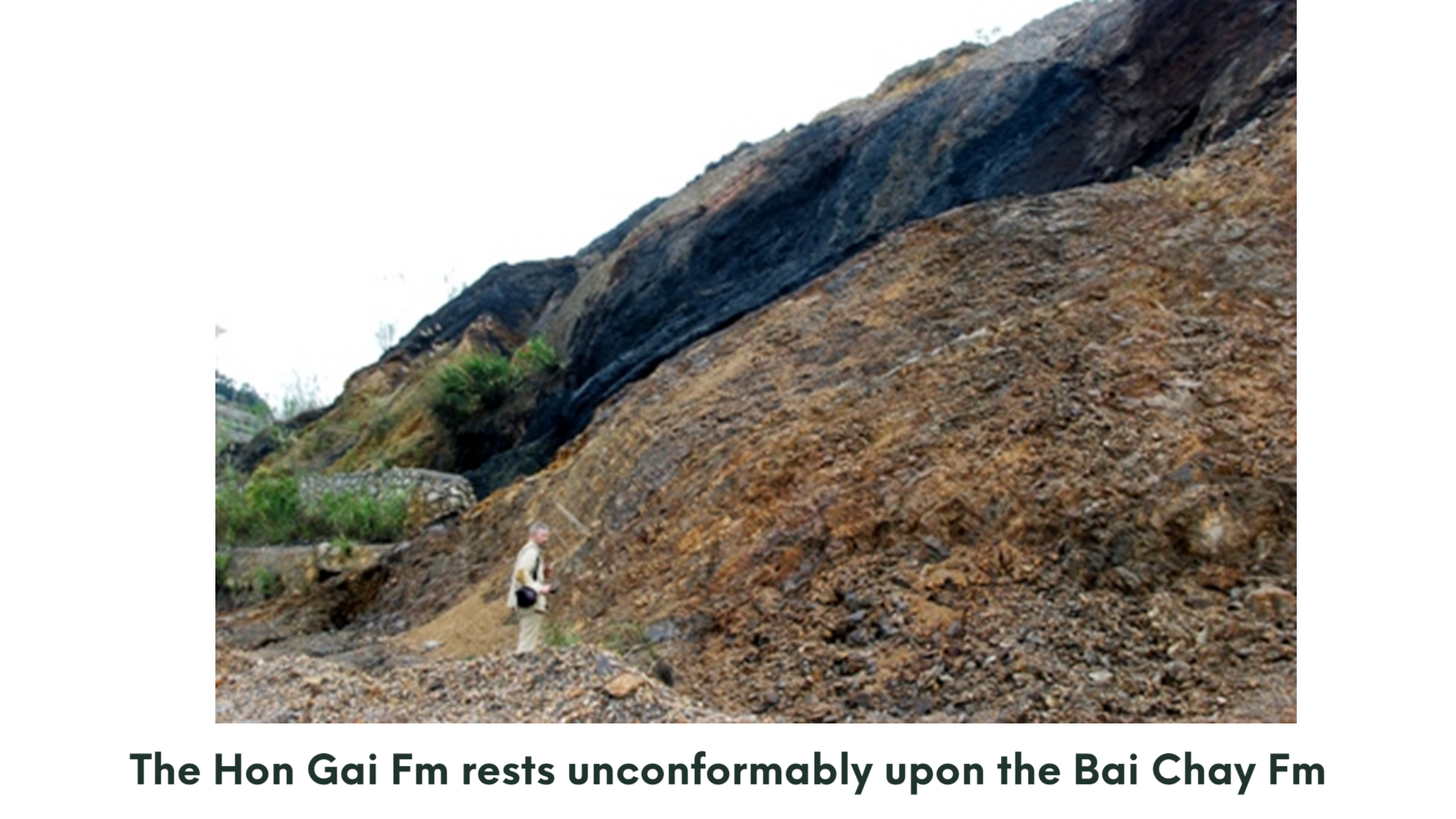
Upper contact
The section is unconformably covered by conglomerate and sandstone of the coal-bearing Hon Gai Fm.
[Figure: Hòn Gai Fm resting unconformably on the Bai Chay Fm (images courtesy of Prof. Ta Hoa Phuong, Vietnam Natl. Univ. Hanoi)]
Regional extent
The Bai Chay Fm occurs in the coastal zone of East Bac Bo in narrow, sublatitudinal trending bands on the limb margins of the Cam Pha - Hon Gai Syncline. The northern band extends from Quang La following Road N2 18B to Vu Oai; the southern band extends along the Quang Hanh - Cam Pha car road lying in the hilly zone south of Bai Chay Beach.
GeoJSON
Fossils
In the calcareous chert of this member some Wuchiapingian bivalves have been collected by geologists of the Paleontological Laboratory (Institute of Geology and Mineral Resources), such as Guizhoupecten regular is, G. sp., Stutchburia aff. dianensis, Euchondria sinensis, Bakevellia sp.
Age
Depositional setting
Additional Information